
Setting
The Molly Marie Prospect is located in the Basin and Range Province.
During the Miocene (mid-Tertiary), extensive brine lakes covered most of southern Arizona as shown in the below diagram:

The Colorado River basin had not formed yet, and the water pooled in what is now Arizona, in deep rift zones. Evaporation of these lakes resulted in salt deposits up to 10,000 feet thick at Luke AFB near Phoenix, and the largest gypsum deposit in the world which is found at nearby Picacho, AZ. Another salt deposit is under Higley, AZ, which is now part of Gilbert. Below is a link to an excellent document on the subject:
http://mollymarieprospect.com/Peralta2posting/circular_30-az_has_salt.pdf
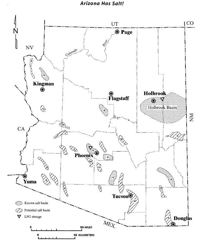
Below is a diagram from the document showing the known and suspected salt deposits of Arizona.
Occurring concurrently with the brine lakes was the active period of the Superstition volcanic field, which was comprised of several iron-rich rhyolitic and dacitic volcanoes, calderas, and fissure eruptions. Some of the lakes engulfed a portion of the Superstition volcanic field, and later eroded several of the volcanoes to their bases.
The Molly Marie Prospect is situated on what was once a submarine volcanic caldera of the Superstition field, which overlies a rhyolitic magma chamber over one mile in diameter. The brine from the lakes leached metals from the volcanic debris , that once was piled over 3000 feet high above the Molly Marie Prospect. This metal-laden brine was combined with circulating hot magmatic fluids rich in iron, and the metals precipitated, creating an IOCG (Iron Oxide Copper Gold) deposit below a layer of basalt(a trap) that is currently exposed on the surface, and in abundant phreatic breccias(another trap). The IOCG formed under shallow water at a relatively shallow rock depth, a situation that is known to greatly enhance gold formation. Underwater hot-springs were abundant and many of the silica mounds that were created by them remain intact on top of the basalt.
The Molly Marie caldera has collapsed over 700 feet, and within and on its perimeter are found abundant hydrothermal silica domes, phreatic arkosic breccias, exhalites, extensive hematite breccias, silica replacement, silica/hematite mounds, copper and gold mineralization, tufa deposits, intense propylitic alteration (chlorite and epidote), and ring dikes.
Near the center of the caldera is a magnetic rhyolitic porphyry stock complex, which is the neck of a strata volcano that has been eroded to the volcano’s base. Surrounding the stock is a large quartz breccia pipe, hematite breccias, and copper and gold mineralization. A very strong magnetic zone 400 to 500 yards wide or more surrounds the caldera which was verified with a magnet that stuck to vertical faces of the Ruin granite.
The enhanced photo below shows the boundary of the magma chamber, the volcanic neck, and the extensive phreatic arkose breccias on the west side of the caldera. The breccias are discussed further in the ore genesis page.

MENU